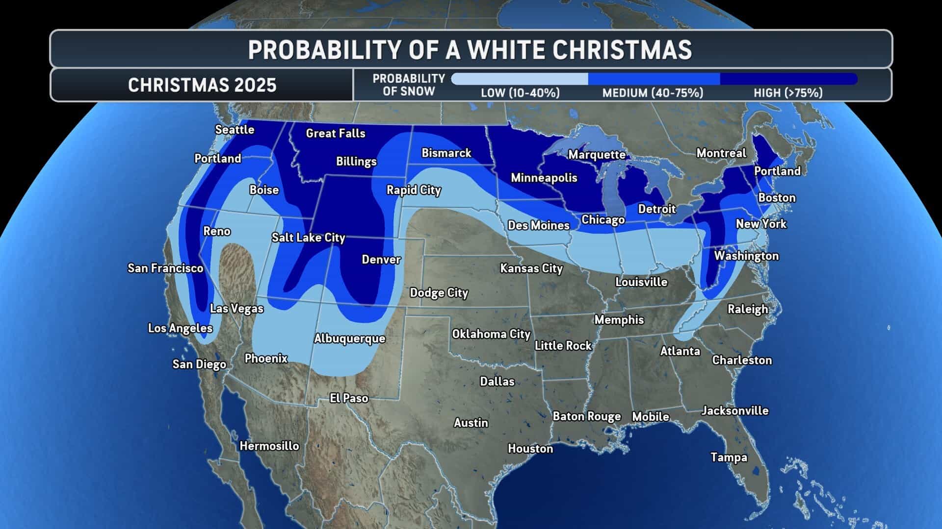
"WeatherAccuWeather forecasters predict a guaranteed White Christmas across the central and northern Rockies, with solid chances near the Great Lakes and higher Appalachians. A pending storm between December 23 and 25 could deliver timely snow to parts of the central and eastern U.S., though warm air threatens to melt earlier accumulations. Snow lovers define a White Christmas as at least one inch on the ground by December 25, including fresh falls that day."
"Rockies and Great Lakes Lead Odds Higher elevations from Wyoming through Colorado lock in snow cover with 40-75% probabilities extending to nearby lowlands. Lake-effect snowbelts downwind of the Great Lakes ensure ground cover on Christmas morning, while New England ridges boost prospects. The Sierra Nevada and Cascades join the Midwest and interior Northeast as top contenders. Warmup Threatens Early Snowpack A warmup sweeps the Plains ahead of Christmas week, pushing east and erasing snow from the December 13-14 storm in the Northeast and mid-Atlantic coasts."
"AccuWeather Lead Long-Range Expert Paul Pastelok notes fresh blankets may wilt before the storm arrives. Storm Track Holds Key Pastelok flags the December 23-25 system as pivotal, with its path deciding snow surges north of Interstate 80. Areas south risk rain, though trailing flurries or dustings could still evoke holiday cheer without hitting the one-inch mark. The forecast starts with a cold, snowy December and transitions to milder patterns."
Central and northern Rockies have the highest likelihood of one inch or more of snow on the ground by December 25, with strong prospects also in Lake Erie/Great Lakes lake-effect belts, higher Appalachians, Sierra Nevada and Cascades, Midwest and interior Northeast. A storm projected for December 23–25 could bring additional snow across parts of the central and eastern United States, but a warmup sweeping east across the Plains threatens to melt earlier accumulations along the mid-Atlantic and southern areas. Snow persistence and precipitation type depend critically on the storm’s track north or south of Interstate 80.
Read at SnowBrains
Unable to calculate read time
Collection
[
|
...
]