"The snowpack builds gradually through the season as layers from each storm settle and compact. When storms are frequent and temperatures stay cold, the snowpack deepens and strengthens. But if the weather turns warm or dry, it may fall short of expectations. Snowpack is measured in two main ways: total snow depth and snow-water equivalent (SWE). SWE is especially important because it quantifies the water actually stored in the snow, providing a clearer picture of how much runoff may be available in spring."
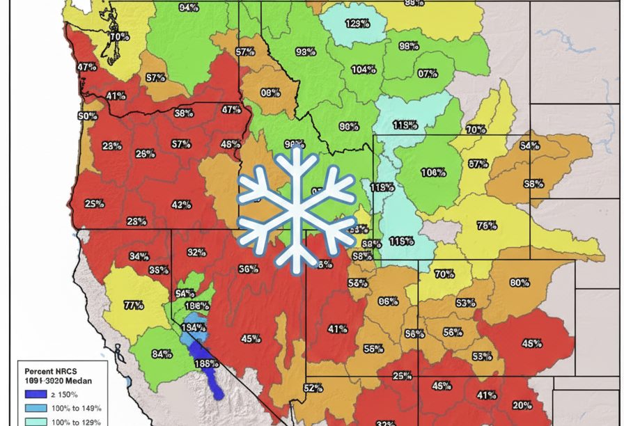
"Much of the Southwest and Pacific Northwest remains in a "snow drought," with snow water equivalent (SWE) levels well below the 1991-2020 median. Oregon, Nevada, Arizona, and New Mexico are particularly hard-hit, with vast areas shaded in red indicating less than 50% of the normal snowpack for this time of year. Arizona and New Mexico show especially concerning figures, while Colorado also remains largely below average, with many basins hovering between 40% and 70%."
Winter across the Western U.S. has begun slowly, leaving January snowpack levels well below typical depths in many areas. Storms have been fewer and weaker than usual, and the cold snaps needed to build and preserve a base have been intermittent. Snowpack accumulates as layers from each storm settle and compact; frequent cold storms deepen and strengthen the base, while warm or dry weather reduces accumulation. Snowpack is measured by total depth and snow-water equivalent (SWE), with SWE indicating stored water and potential spring runoff. Much of the Southwest and Pacific Northwest are in a snow drought, with Oregon, Nevada, Arizona, New Mexico, and parts of Colorado well below the 1991-2020 median, while portions of the northern Rockies show near- or above-median SWE.
Read at SnowBrains
Unable to calculate read time
Collection
[
|
...
]