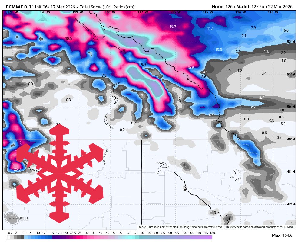
"Lake Louise has the cleanest agreement, with every model producing a prolonged snowfall signal and the current forecast landing at 44 cm to 67 cm for the full cycle. Banff Sunshine also stays favored, but intensity spreads wider there, so the most realistic outcome is still solid snow rather than the most aggressive solution."
"By Friday night into Saturday, the guidance still agrees on colder air pushing snow levels down below 1,000 meters and turning the snow quality much better across the Alberta side. SLRs climb into the 12-18 range in the colder finish, so the back half of the storm should ski lighter than the early dense rounds."
"Snow levels start high, generally around 1,800 to 2,300 meters during the wetter pulses, so the early snow looks dense with SLRs mostly in the 7-10 range and occasional lower periods. Winds are not the headline in this first wave, though Banff Sunshine should still see some exposed-terrain gusts around 40 to 50 km/h while snowfall continues."
The Alberta Rockies are positioned for the best skiing conditions in the current weather cycle, with Lake Louise and Banff Sunshine receiving substantial snowfall through early Sunday. A sustained snowfall event runs from Tuesday afternoon through Saturday morning, with model guidance showing strong agreement on timing and intensity. Early snow will be dense with snow-to-liquid ratios of 7-10, but colder air arriving Friday night will push snow levels below 1,000 meters and improve snow quality to 12-18 ratios. West of the divide, conditions are less favorable, with Kicking Horse receiving only 8-12 cm, Revelstoke 4-7 cm, and Big White and RED receiving minimal refreshes. Wind impacts are minimal during this first wave.
#ski-weather-forecast #alberta-rockies-snowfall #lake-louise-and-banff-sunshine #snow-quality-and-conditions
Read at SnowBrains
Unable to calculate read time
Collection
[
|
...
]