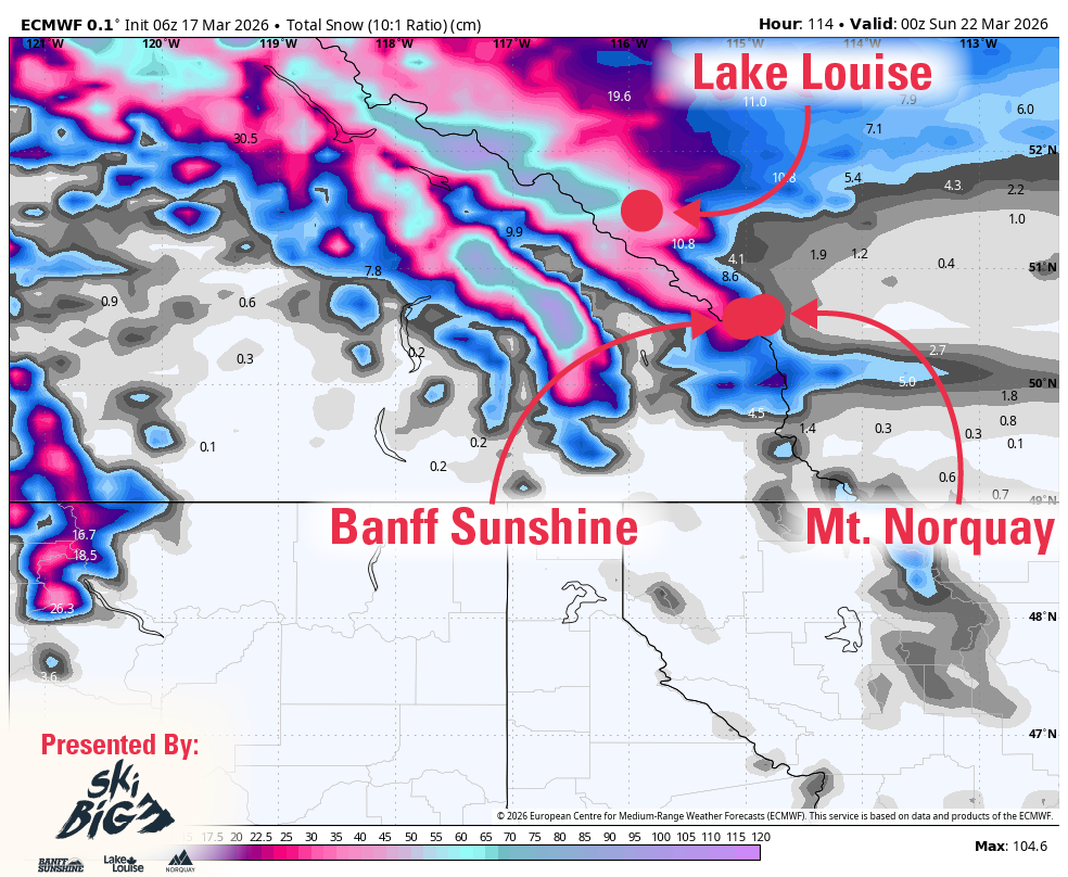
"A multi-wave storm cycle should keep the SkiBig3 active through Saturday, with Lake Louise and Banff Sunshine favored for the best accumulation while Mount Norquay stays more marginal early. Confidence is highest from Wednesday morning through Saturday evening, when guidance is aligned on several rounds of snow, a drop in snow levels from around 1,700 to 2,300 meters to well below base elevations by Saturday, and only moderate wind issues rather than a major shutdown signal."
"The main storm window runs from Thursday night through Saturday, and guidance is still converged on that timing even though snowfall intensity differs from one solution cluster to another. Lake Louise and Banff Sunshine are favored throughout, while Mount Norquay remains the least certain and least productive until colder air settles in. Snow levels bounce around 1,800 to 2,300 meters during the milder part of Friday, then fall below base elevations Friday night into Saturday, so snow quality should improve from dense 5 to 10 SLR snow at first to much nicer 13 to 18 SLR snow."
A multi-wave storm system will impact the SkiBig3 resorts from Wednesday through Saturday with high confidence. Lake Louise and Banff Sunshine are favored for the best snow accumulation, while Mount Norquay remains marginal early in the cycle. Wednesday brings light morning snow with modest intensity. The main storm window runs Thursday night through Saturday with converged model guidance. Snow levels will drop from 1,700-2,300 meters to well below base elevations by Saturday, improving snow quality from dense 5-10 SLR conditions to lighter 13-18 SLR snow. Wind gusts of 30-50 km/h are expected with no major operational concerns. Sunday and Monday will be colder and quieter, with another lower-confidence snow chance around Tuesday night and Wednesday.
Read at SnowBrains
Unable to calculate read time
Collection
[
|
...
]