#bubblemaps
#bubblemaps
[ follow ]
#google-maps #data-visualization #gemini-ai #geopandas #data-analysis #ai #cartography #gemini #weather-apps
fromArchDaily
3 days agoMapping the Technosphere: Architecture as an Interface Between Systems and Territories
Architecture can no longer be conceived as an isolated object, detached from the technical networks that sustain contemporary life. This condition calls for new readings and approaches.
Design
#google-maps


Roam Research
fromSearch Engine Roundtable
1 month agoGoogle Rolls Out "Ask Maps" in Google Maps
Google Maps introduces Ask Maps, an AI-powered feature using Gemini to help users research businesses, plan trips, and get recommendations, now rolling out in the U.S. and India on mobile with desktop coming soon.
fromFast Company
2 weeks agoSee it: Air temperatures and pollution around the world are captured in real time in these animated weather maps
We created Earth in Action to provide a lens into what's happening on our planet, as it happens. Whether it's something typical, like the current air temperature, or an extreme event like a major dust storm, we wanted to provide an opportunity for people to see them.
OMG science
fromArchDaily
1 week agoFrom Data to Digital Twins: Japan's PLATEAU Project Offers Open-Access Models of More Than 250 Cities
Project PLATEAU, led by Japan's Ministry of Land, Infrastructure, Transport and Tourism, aims to develop and expand access to 3D models representing the diversity of cities across the country, enhancing urban resilience and addressing local challenges.
Data science
Business intelligence
fromLondon Business News | Londonlovesbusiness.com
2 weeks agoWhy GIS matters in modern infrastructure and urban planning: Building smarter, future-ready cities - London Business News | Londonlovesbusiness.com
GIS is essential for effective urban planning, enabling data-driven decisions that enhance infrastructure and quality of life in rapidly growing cities.
fromThe New Yorker
3 weeks agoWhy You Hate Your Weather App
In March, we expect mercurial weather- intrat leo, exeunt agnus-but this March has taken things to an extreme. In Washington, D.C., where I live, the weather was eighty-four degrees and sunny one day, then just above freezing and snowing the next.
Apple
Arts
fromThe Art Newspaper - International art news and events
1 month agoNew book shows why physical maps have an important role to play in our digital world
A cartography professor discovered 96 historically significant maps in a forgotten university archive, revealing cartography's vital role in preserving sociopolitical memory and demonstrating maps' importance beyond navigation.
fromAnythingconverter
3 weeks agoAnythingCounter - Real-Time Digital World Statistics with Sources
Approximately 500 tonnes of gold are lost in e-waste every year, which translates to a staggering worth of about $15 billion, highlighting the significant economic impact of electronic waste.
Data science
frominsideevs.com
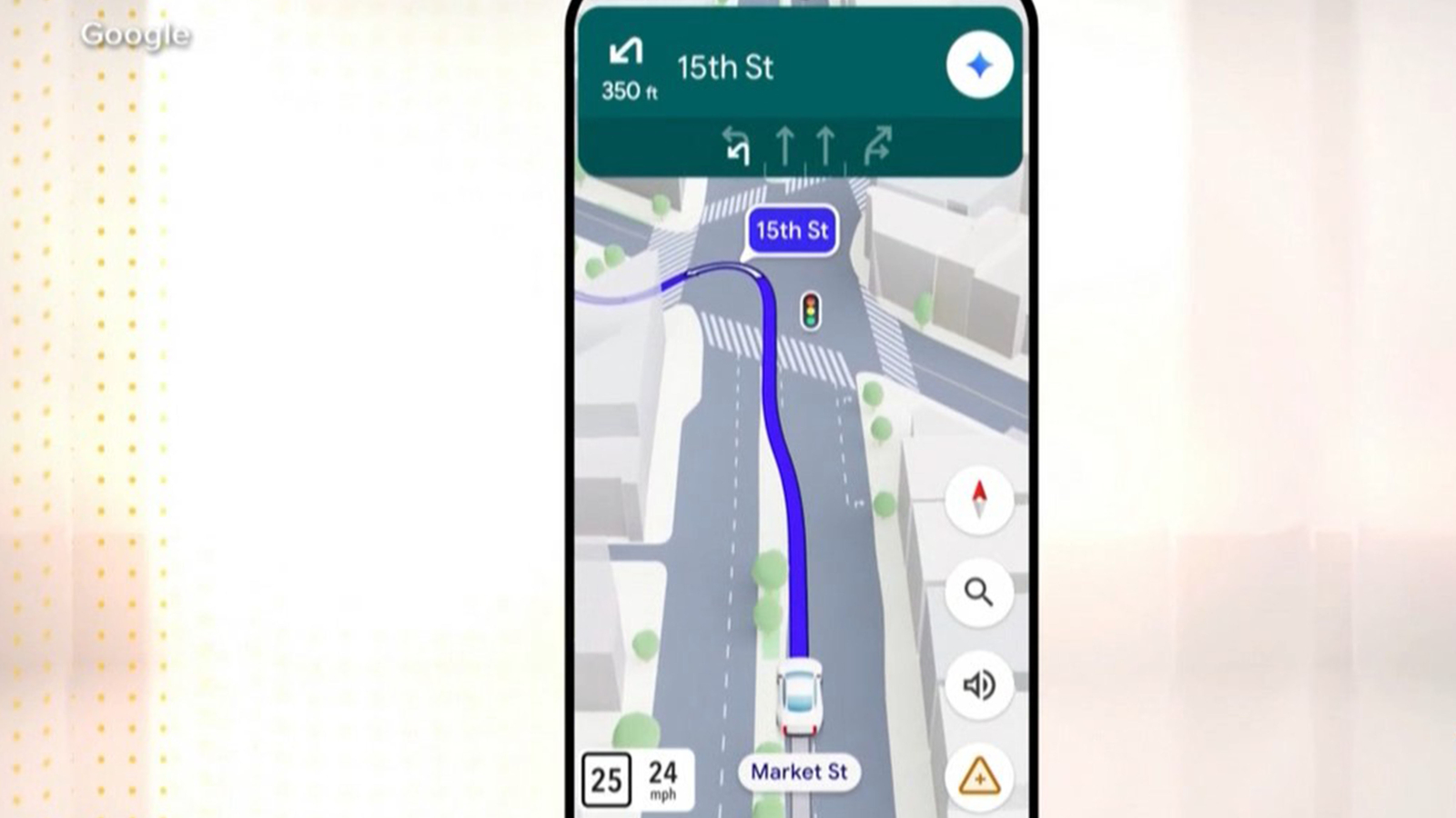
1 month agoGoogle Maps Is Getting 'The Most Significant Update' In Over A Decade
The new Immersive Navigation mode introduces a detailed 3D map that includes buildings, overpasses, crosswalks, traffic lanes, traffic lights, and stop signs. Google bills this new mode as being the most significant update in over a decade to the app's driving experience. According to the American IT giant, the changes should help drivers stay focused and informed on the road, with Maps giving fresh, real-world information and natural directions.
Gadgets
fromEngadget
1 month agoChatGPT will now generate interactive visuals to help you with math and science concepts
Starting today, ChatGPT will generate dynamic visuals when you ask it to explain select scientific and mathematical concepts, including the Pythagorean theorem, Coulomb's law and lens equations. When ChatGPT responds with an interactive visual, you'll be able to tweak any variables and the equation itself, allowing you to see how those changes affect the solution.
Online learning
fromwww.theguardian.com
1 month agoAnalysis finds urban areas in England where no one lives within 15-minute walk of nature
While the data shows 80% of people live within walking distance of green or blue spaces such as a river, park or woodland, it also reveals a disparity between rural and poorer urban areas. In some areas of local authorities, fewer than 20% of residents live close to these spaces, according to data released by the Department for Environment, Food and Rural Affairs on Wednesday.
Environment
Software development
fromBusiness Matters
2 months ago5 Reasons Why Maptive is The Best GIS Platform for Location Intelligence
Maptive transforms spreadsheet location data into fast, browser-based interactive maps and optimized routes, delivering accessible location intelligence without specialized GIS expertise.


New York City
fromFast Company
1 month agoMIT researchers just mapped New York City foot traffic for the first time ever
A comprehensive pedestrian model maps foot traffic across all NYC sidewalks, revealing movement patterns and crash vulnerabilities and enabling people-focused transportation planning and funding shifts.
Brooklyn
fromBrooklyn Eagle
2 months agoPREMIUM Women have been mapping the world for centuries, and now they're speaking up for the people left out of those maps
Women historically contributed to mapping but were overlooked; geospatial technologies and GIS expanded education, employment and research opportunities, increasing women's access to mapmaking.
fromHeat.js
2 months agoHeat.js : JavaScript Heat Map
Completely free and open source (view our licence here). data_object Supports export for integration with frameworks including React, Vue, and Angular. Fully configurable, featuring custom triggers and adjustable text to support multiple language locales. 60 languages supported by default (view the languages here). Includes multiple views, including Map, Line, Chart, Days, Months, and Color Ranges. export_notes Export data to multiple file formats (view the supported types here), with system clipboard setting support.
Web design


Data science
fromLondon Business News | Londonlovesbusiness.com
2 months agoIs Maptive the best mapping software to conduct complex spatial analysis - London Business News | Londonlovesbusiness.com
Maptive delivers cloud-based, no-code spatial analysis and mapping that handles large datasets, automated territories, route planning, and enterprise-grade global mapping infrastructure.
fromMedium
2 months agoWhy Does Using AI Feel Like Cheating when It's Actually Like Google Maps?
AI, like Google Maps, provides the "prediction" of the best route, but the "judgement" of the destination remains with the driver (Author x Gemini) Yet when it comes to using AI for decisions, I see people paralysed by exactly these fears. This ranges from choosing what to study to planning a career move to even planning an article. "Is this cheating?" "Will I lose my critical thinking skills?" or "Am I even thinking for myself anymore?"
Artificial intelligence
fromThedrum
2 months agoHyper-local measurement to optimise catalogue effectiveness
They were trying to get to the bottom of how to diminish catalogue distribution without having a negative impact on store and online sales. They were also keen to define the geographic areas where digital content would work best and how to profile those areas to classify digital purchase behaviour. Together with Analytic Partners they were able to uncover opportunities to eliminate 22% of catalogues with negligible sales impact and increasing digital support in high-performing topologies, preserving€ 294 million in sales.
Marketing tech
fromArchDaily
2 months agoHealth, Habitat, and Civic Infrastructure: Designing the City as a National Park
Cities around the world share a common goal: to become healthier and greener, supported by civic infrastructure that restores ecosystems and strengthens public life. The question is how to reach this. Global climate targets, local building codes, and municipal standards increasingly guide designers and planners toward better choices. Still, many cities struggle to translate these frameworks into everyday, street-level comfort and long-term ecological protection.
Environment
fromCornell Chronicle
2 months agoMaps offer neighborhood-level insight into American migration | Cornell Chronicle
That local exodus is documented by Cornell-led research that mapped annual moves between U.S. neighborhoods from 2010 to 2019 in detail 4,600 times greater than standard public data. Called MIGRATE, the new, publicly available dataset revealed that most of those displaced remained within the affected county - moves not captured in county-level public migration data aggregated every five years.
Data science
fromMedium
2 months agoFrom Graphs to Generative AI: Building Context That Pays-Part 1
Every year, poor communication and siloed data bleed companies of productivity and profit. Research shows U.S. businesses lose up to $1.2 trillion annually to ineffective communication, that's about $12,506 per employee per year. This stems from breakdowns that waste an average of 7.47 hours per employee each week on miscommunications. The damage isn't only interpersonal; it's structural. Disconnected and fragmented data systems mean that employees spend around 12 hours per week just searching for information trapped in those silos.
Data science
[ Load more ]