New York Mets
fromESPN.com
2 hours agoFans of scuffling Mets mostly stay home on chilly N.Y. night
The New York Mets faced a quiet reception from fans as they attempted to end an 11-game losing streak.
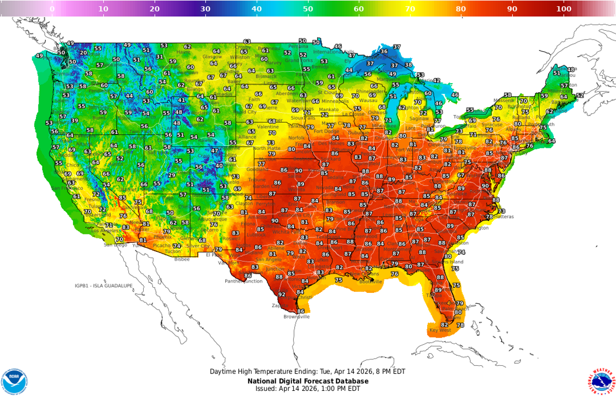
Tri-State Area residents are getting a taste of June with sunshine throughout the week. High temperatures climb into the upper 70s, and with the breeze, it's going to feel much more like June than April.
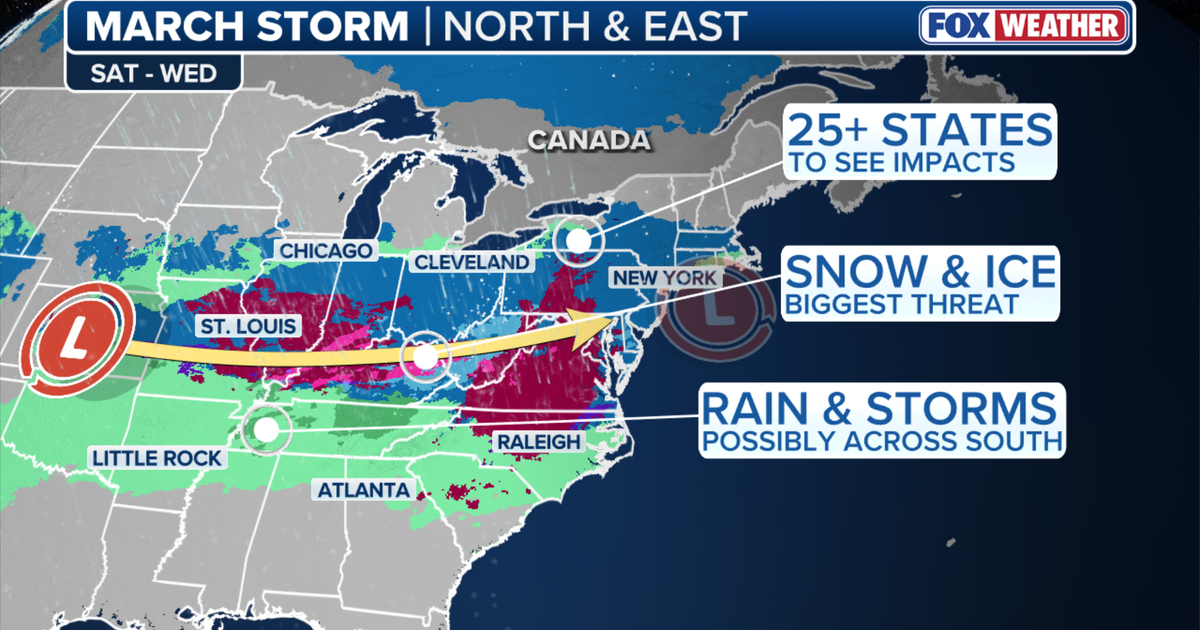
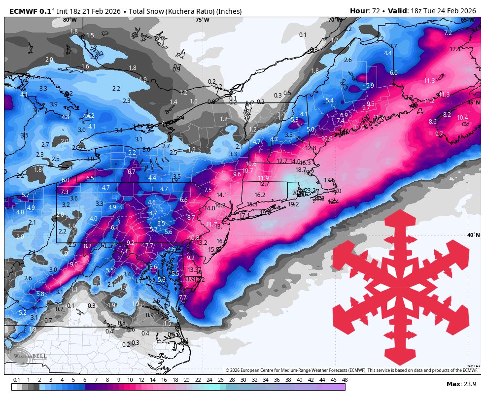
A fast-moving cold front is pushing south out of Canada, sending colder air across the Northeast and Mid-Atlantic, according to FOX Weather. More than 40 million people are expected to feel this 'winter flashback,' with temperatures running 10 to 20 degrees below average through midweek.
But what, exactly, is a blizzard? A blizzard doesn't always mean "a lot of snow," though it can certainly bring heavy snowfalls, as this storm is expected to along parts of the East Coast. Rather, the National Weather Service defines it as a snowstorm with winds regularly above 35 miles per hour and "considerable falling" or blowing snow for at least three hours.
A clipper spreads into northern New Hampshire, western and northern Maine, Vermont, and southern Quebec Friday evening, peaks overnight, and lingers as lighter mountain snow showers into Saturday night. Snow levels generally stay from the surface to about 1,000 feet while it is snowing, so this is a mostly all-snow refresh for every resort in the region.
A high-confidence Friday afternoon through Saturday storm brings a solid shot of snow to much of New England, with improving snow quality as colder air filters in Friday night. Expect a brief period of denser, lower-elevation snow at the onset in the south and along the coast, then a trend to lighter, drier snow overnight as temperatures fall and snow-to-liquid ratios climb.
Sunday and Monday stay sharply cold with only light nuisance snow early, followed by a better but still modest snowfall window Tuesday afternoon through early Wednesday. After that, confidence drops as a broader Thursday night through weekend precipitation cycle arrives with bigger spread on snow versus rain at different elevations.
As we navigate the ebb and flow of New York City's February weather, it is essential to stay informed about the changing patterns and potential disruptions. The National Weather Service has issued detailed forecasts across the boroughs, with cloudy skies and rain likely to be the prevailing theme as we move through the week. Manhattan, Brooklyn, Queens, the Bronx, and Staten Island are all bracing for a mix of showers and potential snow as temperatures hover around the low 40s.
CITYWIDE - NEW YORK CITY RESIDENTS are about to experience another weekend of killing cold, according to the National Weather Service, which has issued an Extreme Cold Watch starting at 6 p.m. Saturday and extending to 1 p.m. Sunday. An Arctic air mass combined with strong northwest winds may produce dangerous wind chills as low as 15 degrees below zero from late Saturday afternoon into Sunday morning.
The National Weather Service forecasts the first snow to begin falling around 9 a.m. Sunday and continue through Monday, with scattered showers possibly lasting into Tuesday. The weather service expects a final total of 14 to 20 inches of snow across the state, with some coastal towns possibly seeing more than 20 inches: The high end of projections call for a potential of 24 inches in Gloucester and other North Shore communities, with Boston possibly seeing 21 inches:
WeatherAs forecasters anxiously watch models for better agreement, one thing is clear: a major winter storm-named Winter Storm Fern by The Weather Channel-is forecast to impact a vast portion of the United States this weekend, bringing a dangerous combination of heavy snow, ice, and extreme cold to much of the country. Winter Storm Fern is expected to impact more than 230 million people across roughly two-thirds of the U.S., stretching across approximately 33 states.