#lidar--sensors
#lidar--sensors
[ follow ]
#autonomous-vehicles #waymo #lidar #robotaxis #precision-agriculture #robotaxi #ai #technology #google-maps #robotics


fromFuturism
1 day agoRobot Dogs Patrolling Precious Crops as Food Crisis Deepens
Bayer is supplementing human security patrols around its 8,000 acre Hawaiian corn farm with robotic security dogs, supplied by the tech firm Asylon. The Asylon dogs are meant to guard the company's precious maize from vandals, wildfires, wild fauna, and other hazards around the clock.
Agriculture


#urban-development
Business intelligence
fromLondon Business News | Londonlovesbusiness.com
2 weeks agoWhy GIS matters in modern infrastructure and urban planning: Building smarter, future-ready cities - London Business News | Londonlovesbusiness.com
GIS is essential for effective urban planning, enabling data-driven decisions that enhance infrastructure and quality of life in rapidly growing cities.
#autonomous-vehicles

fromwww.bbc.com
1 month agoArtificial intelligence
Not even potholes will hold up self-driving cars, UK firm predicts
Wayve raised $1.5bn to expand its AI-powered autonomous vehicle technology, planning London robotaxi launches with Uber while claiming capability to drive anywhere including pothole-affected UK roads.


fromwww.businessinsider.com
2 weeks agoDriverless cars, meet your eye doctor
Kinetic's CEO Nikhil Naikal states, 'We have eyes, and when we need to correct vision, we go to an optometrist... In the same way, this is a digital prescription to correct the errors of the car's understanding of the world around it.'
Cars
fromReadWrite
1 month agoFrom Reactive Repairs to Smarter Home Protection: How Technology Is Changing Roof Care
In the past, roof inspections mostly focused on what could be seen from the outside. Contractors looked for broken shingles, worn flashing, or areas where water might enter the roof. The problem is that roof damage does not always show clear signs right away. Water can move through roofing layers before it becomes visible inside the home.
Renovation
Arts
fromThe Art Newspaper - International art news and events
1 month agoNew book shows why physical maps have an important role to play in our digital world
A cartography professor discovered 96 historically significant maps in a forgotten university archive, revealing cartography's vital role in preserving sociopolitical memory and demonstrating maps' importance beyond navigation.
fromNature
1 month agoObserving the tidal pulse of rivers from wide-swath satellite altimetry - Nature
Along coastlines, where tides are typically magnified, they profoundly affect navigation, commerce, coastal flooding, water properties and sediment transport. Tides impact the flooding of rivers and, thus, influence the extent of their floodplain, which has cascading effects on biogeochemical and ecological processes.
Environment
LA food
fromArs Technica
1 month agoFirefighting drones head to Aspen-can they suppress a blaze before humans arrive?
California's most destructive wildfires occur increasingly frequently, with traditional firefighting methods remaining fundamentally unchanged despite technological advances in monitoring and detection.
fromBusiness Insider
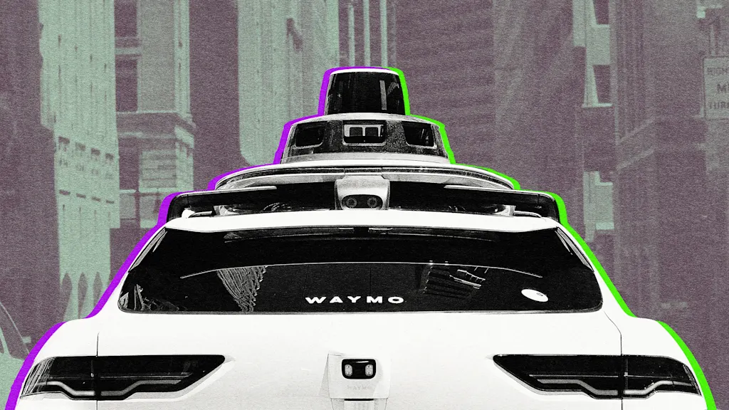
3 weeks agoWhy fully self-driving cars are almost impossible
Despite significant investments and technological advancements, the reality is that no vehicle currently operating on public roads can be classified as fully autonomous. The complexities of real-world driving conditions present insurmountable challenges.
Cars
fromRealagriculture
1 month agoTerraScout brings robot agronomic scouting to the farm
It can drive through the field and look at every square inch. We really honed our craft on model performance and detection with rocks, and now we've transitioned that into weeds. The robot uses a boom-mounted camera system to capture detailed imagery across the field. With eight cameras operating at 1 millimetre resolution, TerraScout can generate billions of data points per acre, allowing it to identify specific objects, including individual weeds.
Agriculture
fromThe Cipher Brief
1 month agoGPS Denied: Time to Upgrade
On February 28, ships navigating the Strait of Hormuz started appearing on tracking screens in places they couldn't possibly be. They appeared to be sitting on airport runways, parked on Iranian land, and clustered at nuclear power plants. More than 1,100 commercial vessels had their navigation systems scrambled in a single day following US-Israeli airstrikes on Iran, bringing a waterway that handles a fifth of the world's oil exports to a halt.
Science
Roam Research
fromTheregister
1 month agoWater company spins out homegrown AI after LLMs failed it
Large language models provided confidently incorrect information about materials science, causing a water desalination startup to waste four months and $200,000 validating a material choice that ultimately proved inferior.
fromNature
2 months agoWhat my cave stay taught me about sensors
To capture the biological impact of this extreme environment, I used a comprehensive suite of sensors and biomarker analyses. I wore a wireless electroencephalograph (EEG) system to monitor brain activity, sleep stages and neural signatures of stress and adaptation; the Oura Ring to continuously track sleep patterns, heart-rate variability and circadian-rhythm shifts; and the glucose monitor to follow metabolic responses in real time.
Wearables
fromTechCrunch
2 months agoLuminar receives a larger $33 million bid for its lidar business | TechCrunch
MicroVision, a Redmond, Washington-based company that has been developing its own lidar sensors, submitted a $33 million bid, eclipsing the $22 million that Quantum Computing Inc. laid out a few weeks ago as the so-called "stalking horse" bidder. (Quantum Computing Inc. had upped its bid to $28 million but apparently was unwilling or unable to go higher.) The sale of Luminar's lidar business will now be subject to approval by the judge in the bankruptcy case.
Business
Gadgets
fromComputerWeekly.com
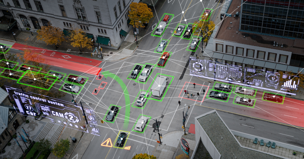
1 month agoConnectivity, AI drive fleet safety, productivity and decision-making | Computer Weekly
AI, connected data, and safety-focused services are transforming fleet operations, with GPS tracking adoption at record highs and AI delivering measurable safety improvements and cost reductions.
Data science
fromLondon Business News | Londonlovesbusiness.com
2 months agoIs Maptive the best mapping software to conduct complex spatial analysis - London Business News | Londonlovesbusiness.com
Maptive delivers cloud-based, no-code spatial analysis and mapping that handles large datasets, automated territories, route planning, and enterprise-grade global mapping infrastructure.
fromFuturism
1 month agoWoman Annoyed When Delivery Robot Comes Into Her Yard, Tears Up Her Garden and Steals Her Fence
I came out here and I found the Coco in my garden. It had got my fence caught up in its wheel. It uprooted a whole bunch of [plants] in my garden and then just drove away with the fence attached to it.
Pets
fromwww.scientificamerican.com
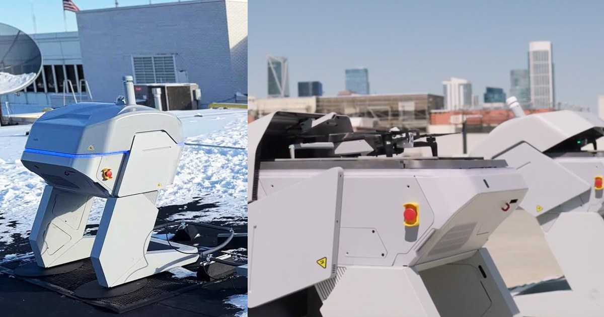
2 months agoHow new AI technology is helping detect and prevent wildfires
Wildfire prevention has traditionally relied on blunt tools, such as rigid inspection cycles and emergency power shutoffs. Now a new generation of technology start-ups is pitching a more targeted approach: using artificial intelligence to help utility companies decide what to inspectand where to intervenebefore a spark becomes a blaze. The stakes are rising. In 2025 more than 77,000 wildfires were reported in the U.S.significantly more than the past decade's averageand burned more than five million acres.
Environment
fromBusiness Insider
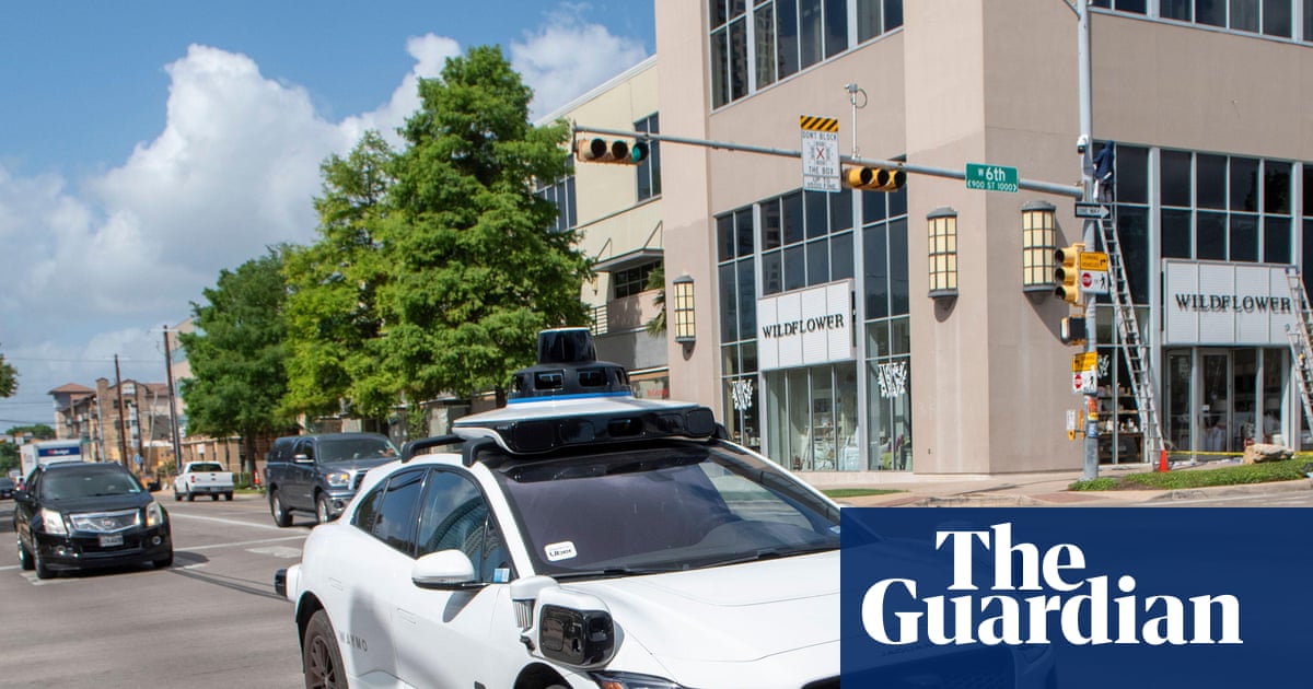
2 months agoRobotaxis are in a literal land grab moment
The robotaxi takeover - assuming they take over - will also be a real estate story. As Waymo, Uber, Tesla, and other competitors race to flood the streets with fully autonomous cars, robotaxi operators will need to find places to park, charge, and maintain their vehicles. Voltera, a charging infrastructure company based in Palo Alto that has partnered with Alphabet-backed Waymo, is buying up real estate now to prep for the AV boom.
Real estate
fromRealagriculture
1 month agoVaderstad expands digital tools for seeding management
You can go onto your cloud account either through the iPad or your desktop computer and pre-plan all your jobs... when your hired man goes into the field he can just pick the job... and then hit start and you can go.
Agriculture
Artificial intelligence
fromeLearning Industry
2 months agoArtificial Intelligence In Transportation Training And Education
AI enables individualized transportation training by evaluating trainee performance, tailoring instruction, simulating real scenarios, and measuring performance for targeted improvement.
fromLondon Business News | Londonlovesbusiness.com
1 month agoWhy long range communication is useful for industrial monitoring - London Business News | Londonlovesbusiness.com
Long-range radio waves can pass through obstacles more easily, which makes them perfect for monitoring expansive factories or outdoor infrastructure. A recent report by Fabrity highlighted that these systems use very little power. This allows sensors to operate for 5 to 10 years on a single battery. Using such tech means you do not have to install expensive wiring across your entire site.
Roam Research
fromBusiness Insider
2 months agoAirbus is making a new handheld tablet for helicopters to act as a hub for drone teams
"We were completely controlling the drone from the helicopter. For us, it's of course unique. Today, what we performed is a world first," Gerin-Roze told reporters on Thursday at the Singapore Airshow. The software is part of Airbus' contribution to the surging industry for drone wingmen, which the world's biggest aircraft manufacturers are betting will be the future of air warfare.
Gadgets
fromdesignboom | architecture & design magazine
2 months agoaerogel-covered drone flies inside burning buildings to help firefighters in rescue missions
FireDrone is an aerogel-covered that can help firefighters in rescue missions by surveying for victims inside burning buildings. The assistive device aims to be the 'flying eye' in extreme environments so humans can be sure of who are and what is inside a site before going in. The FireDrone flying machine resembles a small quadcopter with its four arms and spinning propellers, but unlike regular drones, the parts of the device are built to survive high temperatures.
Gadgets
Agriculture
fromMedium
2 months agoLand Measurement App by Lumen Cluster: Measure Land Easily, Accurately, and Smartly
Smartphone-based Land Measurement App by Lumen Cluster enables fast, accurate, GPS-based land area calculations without specialized equipment, supporting multiple units for diverse users.
Gadgets
fromComputerWeekly.com
2 months agoMyriota introduces satellite-based scalable global asset tracking | Computer Weekly
AssetHawk combines native 5G NTN satellite connectivity with HyperPulse to deliver affordable, rapid-deploy satellite asset tracking for global visibility beyond cellular networks.
fromwww.scientificamerican.com
1 month agoHow LabOS AI-powered smart goggles could reduce human error in science
Laboratory safety goggles have finally joined the ranks of smart devices. That's the promise behind LabOS, an AI operating system for scientific laboratories built by the Stanford-Princeton AI Coscientist Team, a group led by Stanford University bioengineer Le Cong and Princeton University computer scientist Mengdi Wang, with founding partners that include NVIDIA. Powered by NVIDIA's vision-language models to process visual data, the system is designed to provide AI with real-time knowledge of lab work so it can determine what causes experiments to fail or succeed and rapidly train new scientists to expert levels by guiding them through experimental protocols.
Artificial intelligence
Agriculture
fromRealagriculture
2 months agoWithout a coordinated approach, Canada is falling behind on ag tech and drone adoption
Canada requires a coordinated national ag tech innovation and adoption framework plus aligned drone and AI regulations to maintain farm competitiveness and global market access.
fromRealagriculture
2 months agoThe Final Mile, Ep 2: Finding agriculture's real AI advantage, with Mohamed Yaghi
Yaghi describes AI not as a silver bullet, but as an advanced form of statistical pattern recognition-tools that can identify trends in data that may be difficult or time-consuming for people to uncover on their own. The real opportunity, he says, depends heavily on what farms are already doing. Operations that are consistently collecting and digitizing high-quality data are better positioned to benefit, whether the goal is lowering per-cow costs in a dairy, improving financial analysis, or identifying operational efficiencies.
Agriculture
[ Load more ]