#citymapper
#citymapper
[ follow ]
#public-transportation #google-maps #new-york-city #transportation #infrastructure #autonomous-vehicles #ai


fromianVisits
5 days agoTunnel to Heathrow could be privately funded under revived rail link plans
The study concludes that the rail link could deliver strong economic returns under both two-runway and three-runway expansion scenarios at Heathrow Airport, indicating its potential impact on regional connectivity.
UK politics
Alternative transportation
fromLondon Business News | Londonlovesbusiness.com
4 days agoWhy a fuel card makes sense for small delivery and taxi businesses - London Business News | Londonlovesbusiness.com
Fuel cards provide small fleet owners with better visibility and control over fuel expenses, helping to manage tight profit margins effectively.
London startup
fromLondon Business News | Londonlovesbusiness.com
4 days agoWhy London businesses are building their own software instead of buying it - London Business News | Londonlovesbusiness.com
London's small and mid-sized businesses are increasingly opting for custom software solutions over off-the-shelf tools.

Business intelligence
fromLondon Business News | Londonlovesbusiness.com
2 weeks agoWhy GIS matters in modern infrastructure and urban planning: Building smarter, future-ready cities - London Business News | Londonlovesbusiness.com
GIS is essential for effective urban planning, enabling data-driven decisions that enhance infrastructure and quality of life in rapidly growing cities.
fromArchDaily
6 days agoFrom Data to Digital Twins: Japan's PLATEAU Project Offers Open-Access Models of More Than 250 Cities
Project PLATEAU, led by Japan's Ministry of Land, Infrastructure, Transport and Tourism, aims to develop and expand access to 3D models representing the diversity of cities across the country, enhancing urban resilience and addressing local challenges.
Data science
#electric-buses
Alternative transportation
fromSustainable Bus
4 days agoCopenhagen achieves 100% electric bus network as Movia deploys 62 new units - Sustainable Bus
Movia has deployed 62 electric buses, achieving 72% electrification of its fleet and completing the transition of all municipal bus lines in Copenhagen to electric operation.
frominsideevs.com
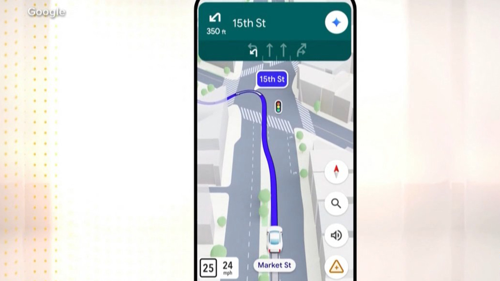
1 month agoGoogle Maps Is Getting 'The Most Significant Update' In Over A Decade
The new Immersive Navigation mode introduces a detailed 3D map that includes buildings, overpasses, crosswalks, traffic lanes, traffic lights, and stop signs. Google bills this new mode as being the most significant update in over a decade to the app's driving experience. According to the American IT giant, the changes should help drivers stay focused and informed on the road, with Maps giving fresh, real-world information and natural directions.
Gadgets
London
fromLondon Business News | Londonlovesbusiness.com
3 weeks agoBuilding a smarter London: How embedded systems are driving urban innovation - London Business News | Londonlovesbusiness.com
Embedded systems integrated into London's infrastructure enable real-time monitoring and intelligent decision-making, transforming transport, energy, and logistics to reduce costs and emissions.
Roam Research
fromFast Company
4 weeks agoGoogle Maps and Apple Maps are making parking harder than it has to be
Navigation apps lack parking guidance, causing drivers to waste time searching for spots and increasing traffic pollution; MIT research demonstrates that providing probability-based parking recommendations could improve travel decisions and reduce congestion.
fromwww.bbc.com
2 months agoCalls to withdraw fresh floating bus stop guidance
The design, which has a cycle lane between the stop and the kerb, is intended to allow bus passengers to get on and off safely while cyclists continue moving. Sarah Gayton, street access campaign co-ordinator at the National Federation of the Blind of the UK, said: "It does not address the concerns that blind and visually impaired people have and it's totally insulting to think that we'll accept this."
UK politics
fromZDNET
1 month ago41 hidden Google Maps settings and features every power user should know
After writing about Google Maps for nearly 15 years, I've learned firsthand that it's packed with hidden settings, menus, and toggles. Many help you fine-tune the app to your liking, while others unlock new features you probably didn't know existed.
Roam Research
[ Load more ]